July 19, 1999 - Monday
Sandstone Creek Hike (See map)
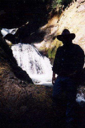
7/19/99 "Hike" up Sandstone Creek. Trapper Steve
Kiley in shadow. What you see is what we got.Long day with Trapper Steve. He drove. Will be his last outing for at least a month. Rest of the week busy and then three week vacation to visit family in Wisconson.
Steve wanted to explore upper Sandstone Creek as a "route" down from Skookum Lake. What a hike. Steep, slick, smooth rocks, washdowned trees, thick vegetation and plenty of Devil's Club. Very dangerous to the point of being foolhardy. One slip would mean a broken bone or worse. Getting someone hurt out of that narrow mess would have been difficult.
However, it was beautiful. Waterfalls, moss, salmonberry bushes, old growth timber. We decided it was too steep to have been logged. Finally turned around where I was crawling up about a 40' dirt bank by grabbing hold of roots and pulling myself along on my stomach trying to get to the crest of the rise. A slip from there was down the bank, bounce off a really big fallen log and then into the creek and the rocks. I could see over the crest and my arm was reaching and I just couldn't get hold of the last root. I was about a foot short and when I tried to buck myself up, I started down. Caught a root and that was the end of the uphill work.
Later, on the topo map, we found we had taken 1 ½ hours to go only about ½ mile on the up route. Coming down was faster. We were both absolutely exhausted when we got to the truck.
Drove to the camera site road and walked in. No pics. No disturbed meats or fish. Steve laughed when he saw the woodsland buffet. After the work up Sandstone Creek, what was an easy walk of about ½ mile one way, was a struggle. No fresh tracks. Game has moved uphill.
Beautiful drive up to Burnt Granite. We decided to rest up a bit and try to find the Thomas site. Saw a scree field up above Tarzan Springs that hadn't seen before. Investigate some time. Quality uphill hike to that spot too.
Stopped by the big rock quarry. Not trashed or shot up. Easterly view, high. Excellent for summer camping. About 2 acres. Flat. Might get windy. Different terrain all around. Some sheer rock cliffs behind it, upslope.
Took the spur road and parked. About a ¼ mile walk up to the Thomas site through some very picturesque regrowth. Big scree. Only one deep hole. Piled rocks looked recent. Some still showed dirt and lichen from where they were overturned.
Road had only been open for about 10 days. Rituals already? Native American? Whites? Continuing over the years? Who? Road was not open for the summer solstice on June 22nd. Did they walk up? Were they the recent work of some BHB's? Other causes?
Lots of root mass holes in the area. Didn't find any evidence of bedding, although Steve found some fresh digging. No bear tracks.
Very tired. Afraid of slipping on the jumbled rocks. Nothing to grab, slip and break something.
Went walking past the scree out toward the point of the mountain. Too far to go all the way. Found some more screes hidden in the trees. Much bigger than the Thomas site. Lots of piled rocks, but too tired to really do much good looking around. Safety important.
Saw an excellent access road into the basin to the NW of Burnt Granite. Might be closed (it is and has stayed closed). Long walk in. Mountain bike? No got right now. Good animal holding area.
We found deer tracks up on top. Where were they getting their water?
Drove around to the other crest of Granite Peaks. Could look down into the Collawash River basin. We decided to backtrack. The tree blocking the road might still be there.
All website content is © Copyright 2000, Joseph Hector Beelart, Jr. unless otherwise noted.
All rights reserved.Pages created and maintained by